Lower Pinn
This webpage was last reviewed in August 2025. The Environment Agency are working with their consultants, Jacobs, to refine the costs and benefits of the options to manage flood risk. We anticipate this work will be complete by the end of 2025 and we will then be in a position to provide a more detailed update about the next steps for the project. Thank you for your patience.
Overview:
The Environment Agency is working with Jacobs to understand the causes of flooding to communities in the Lower Pinn area and to identify effective solutions to reduce this flooding in the future.
Our current short list of options for the area has been assessed by Jacobs. They have used computer models to understand the current flood risk and then assessed the risk with the options in place. We will now be using this information alongside knowledge of how and where flooding happens in the catchment to determine the best option(s) to take forward. Any options to reduce flooding must be shown to be cost beneficial. This is an important step that the project team must go through before deciding to deliver options on the ground.
We will be able to provide further information and gain feedback on the options in 2026.
Flood risk – past, present, future
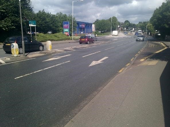
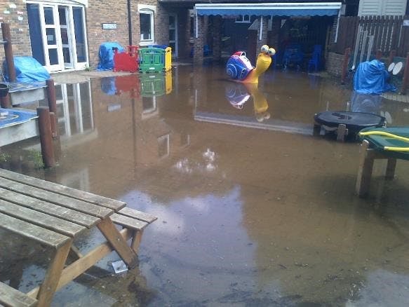
Flooding can have a devastating impact on people's lives. Communities in the River Pinn catchment have experienced flooding several times, with 2016 being the most severe in recent memory. The photo gallery to the right shows the impact this had on the communities in the Lower Pinn. Additional guidance relating to flood risk and modelling can be found in the ‘What is modelling’ and 'FAQs' documents to the right.
The most recent climate change predictions confirm there will be wetter winters and drier summers, with an increased likelihood of more intense rainfall leading to flooding. Flood risk is therefore likely to increase, adding an urgency to deliver an effective option to manage flood risk. We will build climate change projections into the design of any options we plan to deliver to make sure they are fit for the future.
Engaging with communities
What have we done so far?
Since the formal consultation in 2018, we have:
- Provided communities with updates through our River Pinn project information webpage.
- Collaborated with partners, including Hillingdon Council to ensure we are aware of all projects which are being progressed in the area.
- Launched this platform to maintain effective and targeted engagement throughout the pandemic and for the lifetime of the project
- Maintained our contact list of those interested in the project so we can provide targeted updates when we have new information to share.
What will we do?
- We will continue to collaborate with key partners to find options to manage flood risk in the Lower Pinn.
- We will update this webpage as more information about the future approach in this area becomes clearer. By signing up to be kept informed you will receive an automatic notification when new information is shared.
- We will continue to work with communities and other partners to secure funding. As we are unlikely to be able to find an option in this area which is fully funded by central government, we will need to consider other funding sources.
Current project progress
Appraisal timeline
The Environment Agency are currently finalising the contract with Jacobs to enable them to undertake the work necessary to proceed to development of an Outline Business Case (OBC).
The OBC details the assessment of the short-listed options and the selection of the preferred option to be taken through to a Full Business Case (FBC) and detailed design.
We have produced an ‘appraisal process’ document explaining the process we go through when developing a project, including what is included in this current phase. This can be accessed from the document section on the right-hand side. The diagram below shows the steps in this process which have been completed for this project.

The project has completed stage 6 and is now starting work on stage 7, which is outlined below:
7. Compare and select the preferred option or combination of options
This is a decision-making process involving stakeholders and local communities. It involves comparing the costs and benefits of the short-listed options to identify the option that provides the best overall outcome, usually the option which best meets the objectives defined at Step 2. The decision-making process follows criteria set out in government guidance which helps to ensure that a consistent approach is used.
As outlined above, we will be able to share more information on the options in 2026 once we have preferred option(s) to share. This page will be updated, and targeted emails will be sent out to our mailing list when this information is live.
Thank you for taking the time to read through our site. If you cannot find an answer to your question(s) on this page, you can email the team at lowerpinn@environment-agency.gov.uk and a member of the project team will get back to you.